Istanbul Metro Maps & Transportation Guide

Istanbul Metro Maps & Transportation Guide
Istanbul Metro Maps & Transportation Guide
Go to Download page and download any of the Istanbul Metro maps you want. From M1 Metro to M9 Metro and M11 Istanbul Airport Metro Map
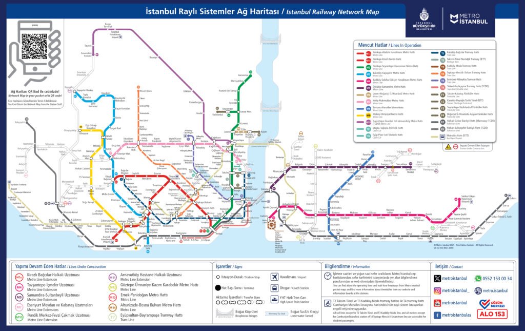
Istanbul Metro Map (Updated)
The Istanbul Metro network continues to expand every year. New lines connect important districts, airports, and tourist attractions.
Here you can find:
-
The latest Istanbul Metro Map
-
Line colors and route connections
-
Transfer points between metro, tram, and Marmaray
-
Printable and mobile-friendly versions
 View the full Istanbul Metro Map
All Istanbul Metro Lines
Istanbul’s metro system consists of multiple lines, each serving different parts of the city.
Popular Metro Lines
-
M1 – Yenikapı ↔ Atatürk Airport
-
M2 – Yenikapı ↔ Taksim ↔ Hacıosman
-
M4 – Kadıköy ↔ Sabiha Gökçen Airport
-
M11 – Istanbul Airport ↔ City Center
Each line has:
-
Station lists
-
Travel times
-
Tourist attractions nearby
-
Transfer information
Explore all Istanbul Metro Lines
Airport Transportation by Metro
Getting from Istanbul’s airports to the city center is now easier than ever.
Istanbul Airport (IST)
The M11 Metro Line connects Istanbul Airport with central districts quickly and comfortably.
Sabiha Gökçen Airport (SAW)
The M4 Line provides a direct metro connection to the Asian side.
You’ll find:
-
Travel times
-
Ticket costs
-
Best routes to hotels
-
Alternative transport options
Airport Metro Guide
Istanbul Metro Fares & Istanbulkart
To use the metro, you need an Istanbulkart.
With one card, you can travel on:
-
Metro
-
Tram
-
Bus
-
Marmaray
-
Ferry
Here you’ll learn:
-
Ticket prices
-
How to buy Istanbulkart
-
How to top up
-
Tourist discounts
Istanbulkart & Fares Guide
Metro for Tourists
The Istanbul Metro is perfect for sightseeing.
Popular tourist routes include:
-
Airport → Sultanahmet
-
Taksim → Historic Peninsula
-
Kadıköy → Bosphorus ferries
-
Galata → Old City
We provide:
-
Step-by-step routes
-
Station exit guides
-
Walking directions
-
Attraction maps
Metro Routes for Tourists
Station Guides
Some stations are more than just transport hubs — they are gateways to Istanbul’s most famous sights.
You can explore:
-
Taksim Station – Istiklal Street
-
Sultanahmet Station – Blue Mosque & Hagia Sophia
-
Kadıköy Station – Asian Side
-
Galata Station – Galata Tower
Each station guide includes:
-
Exit information
-
Nearby attractions
-
Restaurants
-
Transfer options
Istanbul Metro Stations Guide
Operating Hours & Night Metro
The Istanbul Metro runs from early morning until late at night.
Some lines operate 24 hours on weekends.
Find out:
-
First & last train times
-
Night metro lines
-
Holiday schedules
-
Service updates
Metro Operating Hours
Download Metro Maps
Do you need offline access?
Download:
-
PDF metro maps
-
Tourist-friendly maps
-
Printable station plans
Download Istanbul Metro Maps
Latest Istanbul Metro News
Stay updated with:
-
New line openings
-
Construction updates
-
Temporary closures
-
Route changes
Istanbul Metro News